 RBINS metadata catalog
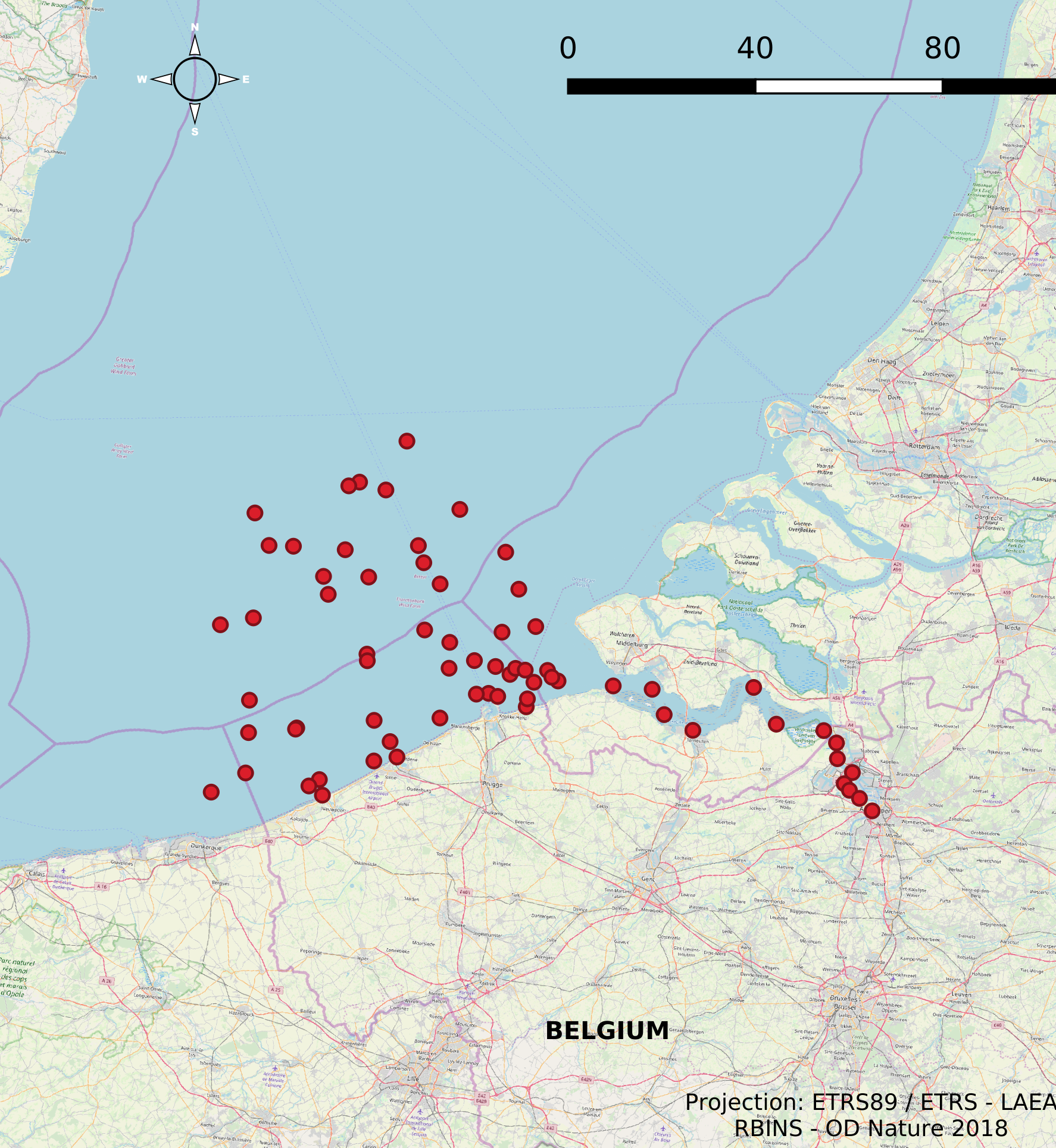
Monitoring stations (operated by MUMM/OD Nature)
The Scientific Service Management Unit of the Mathematical Model of the North Sea of the Royal Belgian Institute for Natural Sciences has been operating monitoring stations on the Belgian Part of the North Sea since the 1970s. These stations are located in the Scheldt estuary, at open sea and in coastal waters. In 2007, 10 new stations were designated and were placed in the monitoring network needed for the OSPAR convention, the Water Framework Directive and the Marine Strategic Framework Directive. These replaced a series of 54 previous monitoring stations whose data was gathered throughout the years for the Belgian Monitoring Programme and reported according to the recommendations of the OSPAR Convention. This dataset contains information on all monitoring stations ever used by the Scientific Service Management Unit of the Mathematical Model of the North Sea. The dataset provides location, name, operational history and for which reporting obligations they are used.
Simple
- Date (Creation)
- 2021-11-18
- Date (Revision)
- 2026-06-08
- Date (Publication)
- 2026-06-16
- Date (Creation)
- 2016-05-19
- Unique resource identifier
- https://doi.org/10.24417/8b317fed-fd7e-4374-a378-4831ff458c09
- Identifier
-
http://metadata.naturalsciences.be
/
8b317fed-fd7e-4374-a378-4831ff458c09
Belgian Marine Data Centre
- Other citation details
-
This dataset is composed of the following sources: ILVO (n.d.). Monitoring networks in the Belgian Part of the North Sea (MUMM).
- Theme
-
-
Federal government
-
Marine essentials
-
Reporting INSPIRE
-
- Use constraints
- Other restrictions
- Other constraints
- No conditions apply to access and use
- Other constraints
- https://creativecommons.org/licenses/by/4.0/
- Access constraints
- Other restrictions
- Other constraints
- No limitations on public access.
- Use limitation
-
No conditions apply to use.
- Classification
- Unclassified
- Spatial representation type
- Vector
- Metadata language
- English
- Topic category
-
- Environment
- Oceans
))
- Extent type code
- Yes
- Date
- Unique resource identifier
- North Sea
- gml32:beginPosition
- 2014-01-01
- Reference system identifier
- http://www.opengis.net/def/crs/EPSG/0/4258
- Distribution format
-
-
application/xml
(
Unknown
)
-
application/xml
(
Unknown
)
Distributor
- Name
-
application/xml
- Version
-
Unknown
- Transfer size
- 0.264682
- OnLine resource
-
od_nature:monitoring_stations_MUMM
(
OGC:WMS
)
A WMS service to view a map
Distributor
- Name
-
application/xml
- Version
-
Unknown
- Transfer size
- 0.117174
- OnLine resource
-
od_nature:monitoring_stations_MUMM
(
OGC:WFS
)
A WFS service to download
- OnLine resource
- Digital Object Identifier (DOI) ( DOI )
- Hierarchy level
- Dataset
Conformance result
- Date (Publication)
- 2010-12-08
- Explanation
-
See the referenced specification
- Pass
- Yes
- Statement
-
The dataset has been merged from several existing ESRI shapefiles on monitoring stations, reprojected towards ETRS89-LAEA and saved as a new shapefile. The resulting shapefile has been reviewed by a senior cartographer. The dataset is offered as the resulting shapefile and an INSPIRE-harmonized GML file.
- File identifier
- 8b317fed-fd7e-4374-a378-4831ff458c09 XML
- Metadata language
- English
- Character set
- UTF8
- Hierarchy level
- Dataset
- Date stamp
- 2026-06-16T15:30:08.106Z
- Metadata standard name
-
Geographic information -- Metadata
- Metadata standard version
-
ISO 19115:2003/19139
Overviews
Spatial extent
Provided by
