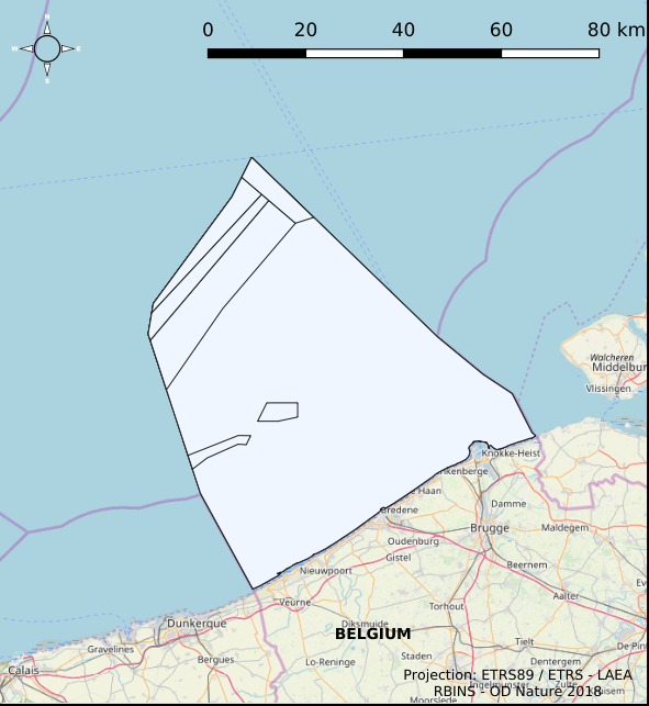
Shipping and ports zones in the Belgian Part of the North Sea
The Royal Decree of 22 May 2019 establishing a marine spatial plan defines 20 shipping and ports zones: Shipping regular regime (Art. 10§1), Northbound traffic flow starting at separation line 'Noordhinder Sud' (Art. 10§2.1°), Separation zone 'Noordhinder Sud' (Art. 10§2.1°), Precaution zone 'Near Thornton and Blighbank ' (Art. 10§2.10°), Northbound traffic flow starting at separation zone 'Off Noordhinder' (Art. 10§2.2°), Separation zone 'Off Noordhinder' (Art. 10§2.2°), Southbound traffic flow starting at separation line 'Off Noordhinder' (Art. 10§2.2°), Precaution zone 'Noordhinder Jonction' (Art. 10§2.3°), Eastbound traffic flow starting at separation line 'At West Hinder' (Art. 10§2.4°), Eastbound traffic flow starting at separation zone 'At West Hinder' (Art. 10§2.4°), Precaution zone 'At West Hinder ' (Art. 10§2.4°), Separation zone 'At West Hinder' (Art. 10§2.4°), Westbound traffic flow starting at separation line 'At West Hinder' (Art. 10§2.4°), Area to be Avoided 'At West Hinder' (Art. 10§2.6°), Deep water route 'Westerschelde approach' (Art. 10§2.7°), Border line 1 of two-way shipping lane 'Westpit' (Art. 10§2.8°), Border line 2 of two-way shipping lane 'Westpit' (Art. 10§2.8°), Precaution zone 'At Gootebank' (Art. 10§2.9°), Anchoring zone 'Oostdyck' (Art. 10§3.1°), Anchoring zone 'Westhinder' (Art. 10§3.2°). It replaces the 2014 Marine Spatial Plan, which is included for completeness. The Royal Decree of 20 March 2014 establishing a marine spatial plan defines in its Art. 9, nine zones with regards to shipping and ports: seven shipping zones (Shipping regular regime, Art. 9 § 1; Shipping route Northhinder South, Art. 9 § 2.1°; Shipping route Northhinder junction, Art. 9 § 2.2°; Shipping route Westhinder, Art. 9 § 2.3°; Shipping route Westhinder precautionary area, Art. 9 § 2.4°; Shipping route Westhinder area to be avoided, Art. 9 § 2.5°; Deep water shipping route Western Scheldt approach, Art. 9 § 2.6°) and two anchorage places (Anchorage place 'Oostdyck', Art. 9 § 4.1° and Anchorage place 'Westhinder', Art. 9 § 4.2°). These zones are made available digitally in the resource described by this metadata document. Please refer to the Belgian official gazette (\"Moniteur belge/Belgisch Staatsblad\") for official reference information.
Simple
- Date (Creation)
- 2021-11-18
- Date (Revision)
- 2021-11-22
- Date (Publication)
- 2026-01-27
- Date (Creation)
- 2016-05-19
- Unique resource identifier
- https://doi.org/10.24417/f98d0d0f-cb75-4055-b8e4-d3c31cb96d34
- Identifier
-
http://metadata.naturalsciences.be
/
f98d0d0f-cb75-4055-b8e4-d3c31cb96d34
Belgian Marine Data Centre
- Other citation details
-
This dataset is composed of the following sources: (1) MSP 2014-2020 Shipping and ports zones in the Belgian Part of the North Sea. (2) MSP 2020-2026 Shipping and ports zones in the Belgian Part of the North Sea. (3) SWAP (n.d.). MarineAtlas website.MarineAtlas website. (4) Shipping and ports zones in the Belgian Part of the North Sea.
- Theme
-
-
Marine Spatial Plan
-
Reporting INSPIRE
-
Federal government
- Area management/restriction/regulation zones and reporting units
-
- Use constraints
- Other restrictions
- Other constraints
- No conditions apply to access and use
- Other constraints
- https://creativecommons.org/licenses/by/4.0/
- Access constraints
- Other restrictions
- Other constraints
- No limitations on public access.
- Use limitation
-
No conditions apply to use.
- Classification
- Unclassified
- Spatial representation type
- Vector
- Metadata language
- English
- Topic category
-
- Economy
- Oceans
- Planning cadastre
))
- Extent type code
- Yes
- Date
- Unique resource identifier
- North Sea
- gml32:beginPosition
- 2014-01-01
- Reference system identifier
- http://www.opengis.net/def/crs/EPSG/0/4258
- Distribution format
-
-
application/xml
(
Unknown
)
-
text/html
(
Unknown
)
-
application/xml
(
Unknown
)
Distributor
- Name
-
application/xml
- Version
-
Unknown
- Transfer size
- 0.218439
- OnLine resource
-
imsp:bmsp_shipping_ports_zone
(
OGC:WMS
)
A WMS service to view a map
Distributor
- Name
-
application/xml
- Version
-
Unknown
- Transfer size
- 0.111594
- OnLine resource
-
imsp:bmsp_shipping_ports_zone
(
OGC:WFS
)
A WFS service to download
Distributor
- Name
-
application/xml
- Version
-
Unknown
- Transfer size
- 0.225898
- OnLine resource
-
imsp19:bmsp_shipping_ports_zone
(
OGC:WMS
)
A WMS service to view a map
Distributor
- Name
-
application/xml
- Version
-
Unknown
- Transfer size
- 0.116278
- OnLine resource
-
imsp19:bmsp_shipping_ports_zone
(
OGC:WFS
)
A WFS service to download
Distributor
- Name
-
text/html
- Version
-
Unknown
- Transfer size
- 0.008877
- OnLine resource
-
MarineAtlas website. SWAP
(
WWW:LINK-1.0-http--link
)
An HTTP link to view information
- OnLine resource
- Digital Object Identifier (DOI) ( DOI )
- Hierarchy level
- Dataset
Conformance result
- Date (Publication)
- 2010-12-08
- Explanation
-
See the referenced specification
- Pass
- Yes
- Statement
-
Dataset is quality assured. Dataset corresponds to a digitized version of the information published in the Belgian official gazette ("Belgisch staatsblad/Moniteur belge"). Only the information published in the official gazette has legal validity.
- File identifier
- f98d0d0f-cb75-4055-b8e4-d3c31cb96d34 XML
- Metadata language
- English
- Character set
- UTF8
- Hierarchy level
- Dataset
- Date stamp
- 2026-01-27T16:29:47.054Z
- Metadata standard name
-
Geographic information -- Metadata
- Metadata standard version
-
ISO 19115:2003/19139
Overviews

Spatial extent
))
Provided by

 RBINS metadata catalog